The local government of Louisville is using a new software system to collect data from dozens of sources to prioritize work on vacant, abandoned and degraded properties. With the aim of improving the general appearance of the city and activating investments.
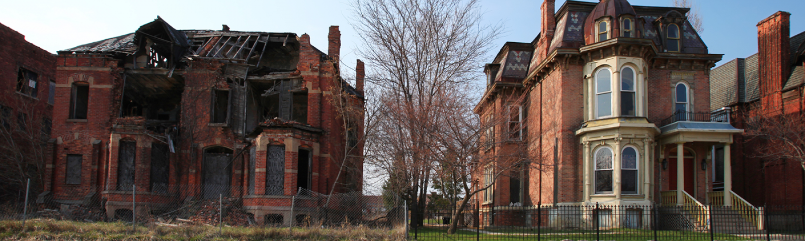
Many governments face many challenges related to vacant properties that have incurred significant losses, They challenge the built environment and restrict investments and vital contributions in many industrial facilities or residential units that are not effectively employed. In this regard, Authorities typically take various measures to settle legal disputes and repair or demolish dilapidated properties. The city of Louisville witnesses, The largest city in Kentucky, Demographic and economic change represented by the growing population and the expansion of investments.
However, this investment expansion is not evenly distributed throughout the city. As the west side of the city does not have a fair share of the development, Other neighborhoods are also suffering from the proliferation of deteriorating real estate. Besides, The city includes more than 6,000 abandoned and deteriorating real estate properties, The local government in Louisville had to work effectively to achieve its strategic plan by reducing the percentage of vacant properties to less than 10%. and revitalize the uninvested western side, By adopting a strategic approach to resource management, This requires employing data more widely.
To this end, The Department of Public and Vacant Properties was tasked with occupying these properties, which represent approximately 2.3% of the potential tax base, and finding solutions using government-owned means such as rehabilitation, foreclosure, and demolition.
The work started from the stage of forming a real understanding of the size and nature of the vacant properties. Which is defined by the local government as real estate that has pending legal violations based on the assessment of a competent employee during a previous field study. The team’s methodology was based on 3 basic criteria that must be met for any action to be taken by the management of public and vacant properties, That the procedure is evidence-based and legally justified, and serve the achievement of the ultimate goal, And to enhance the positive impact on the community surrounding the property.
In order to accelerate the rehabilitation process, The team used the BuildingBlocks application, which uses cloud computing technology to obtain data, He monitored the rates of tax default, and the state of real property through a continuous process of collecting data from disparate sources and records available online, And employ an analytical tool based on digital maps. The application then worked continuously to integrate data from the sources needed by the team to keep up with any changes, including the list of county assessments, And tax information from delays or privileges and any legal violations and the internal workflow management program of the team and others.
In this way, the team was able to review and revise the results on the application interface. Based on the map, Employees can identify eligible properties for properties in just seconds. In the second stage, The team used spatial analysis and data visualization tools to segment properties by neighborhood or area to facilitate the delivery of reports. To determine whether these properties are located in neighborhoods where more than 10% of vacant buildings are located, And to know its proximity to the work sites of other centers of the city government. According to this model, Every property in the city was rated on a scale of 1 to 99, So that the team can coordinate priority properties, Which are simply properties that achieve a high score on what the management called the “mortgage forfeiture scale”, The team prioritized the mortgage forgiveness of a property based on several points, including the length of time during which the property remained vacant, And its location and proximity to vital facilities such as schools and public parks.
In the course of the workflow, The team realized that the information needed to evaluate real estate is distributed among several parties, that it is not possible to obtain them without complex data processing, updating it daily and then analyzing it, The biggest challenge was the lack of technical staff capable of accomplishing these tasks continuously. To study the possibility of forfeiture of mortgage or demolition of real estate, The team needed to identify accessible populations with the tools they had. Which prompted them to include properties with due tax privileges in excess of $1,000, Which has been registered as vacant properties for a period of not less than one year. These decisions have increased the amount of data to be studied. Collecting them requires great effort in addition to the difficulty of other administrative matters such as funding and resource allocation.
To move the project forward, All these challenges had to be dealt with, The team tended to work within the prioritization strategy, By selecting the most nominated properties for foreclosure or demolition, And repeat the process annually.
The use of artificial intelligence has contributed to raising the pace of work, Shortening nearly 10 weeks of human effort to seconds of reviewing the interface of the new system, thanks to it, The team was able to classify nearly two thousand treatable properties using the basic tools available to the department, And add 40-50 additional data points for each property in the city.
Through data collection, The Leweville city government can prioritize it after knowing which properties are at risk. To direct effective investments backed by scientific evidence, Which saves a lot of time, effort and cost, Reducing search time increased the operational capacity of each team member by 60 times. This reflects positively on the actual implementation of the programs.
References:
https://www.tolemi.com/post/louisville-ky
https://the-atlas.com/projects/using-data-to-combat-blight-improve-neighborhoods