an economy dependent on climate-sensitive resources, Natural disasters that increase in intensity and frequency with each passing day, The Philippine government is leveraging information technologies to build resilience to these disasters.
Every year, Natural disasters cause enormous loss of life, property and infrastructure. With the new reality imposed by climate change and contemporary lifestyles, Ensuring recovery for all requires a better understanding of the implications of government policies.
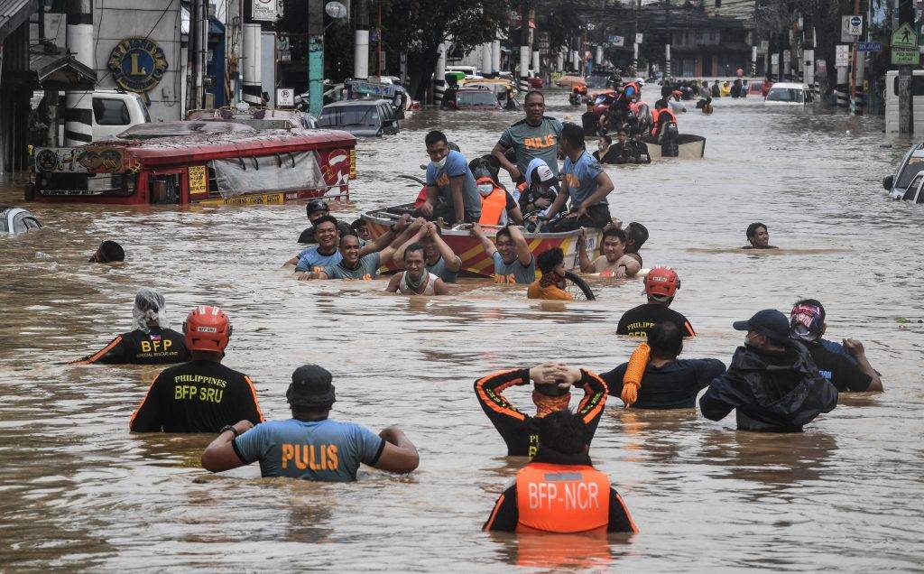
Because they are located in the Pacific hurricane belt, The Philippines has a large share of storms, floods, earthquakes and other phenomena that threaten 60% of its territory and 75% of its population. Over the past decade, it is repeated 19 times a year. Natural disaster records for 2021 indicate that the second most dangerous disaster in the world was Typhoon Rai, which devastated Philippine islands and coastal communities and caused flooding that flooded city streets and caused significant damage to buildings, bridges and private property.
These disasters have a ripple effect on the poor classes, who accounted – until 2020 – more than 16% of the population, When the Philippines had one of the region's most dynamic economies, That is, before the Covid-19 pandemic, which reduced consumption, investment, exports, tourism and remittances, and increased poverty and unemployment rates.
Where climate change increases the frequency of these threats, The Philippine government strives to prevent natural disasters, The Ministry of Science and Technology launched the government's "Georisk" initiative, To build a central database to help predict and prepare for natural disasters, In collaboration with the Philippine Institute of Volcanology and Seismology, The Institutional Strengthening and Community Empowerment Programme against Disasters and Climate Change, It is an initiative launched by the Australian Government and the United Nations Development Programme in the Philippines to serve the same goal.
The name of the initiative refers to the geospatial risks to which the country is exposed, They aim to collect them, with other relevant data, Within a repository of information, Establish a flexible mechanism for sharing data between different entities.
Via Geo Risk, Users can tell if a site is vulnerable to natural hazards. They can see enlarged images of roads, bridges, homes and other infrastructure that could be damaged in the event of a disaster. While government entities take approximately two days to prepare a risk assessment report, This software performs the same task in a quarter of a minute.
Because some are better able to understand and remember visual data, The database creates maps, charts and graphs of impending disasters, Identify the most vulnerable areas, populations and public facilities to help users understand and prepare for them.
In the same vein, The Ministry collaborated with the Philippine Council of Industry, Energy and Emerging Technologies and Maboa University to design a comprehensive building health assessment and registration program. NAMED USHER, Which aims to address concerns related to the condition of buildings before and during earthquakes, and in its wake. The Philippines is proud that the team that worked on this program includes a group of local experts and engineers.
The technology, which has been installed in 160 locations so far, includes, Advanced accelerometer, online portal and mobile apps, They can be installed in constructed structures of any type or age, It allows developers and civil engineers to monitor them from anywhere, anytime.
Similarly, The Ministry has developed a rapid assessment system for earthquake damage, She called it REDAS. This system will simulate the manifestations and hazards associated with earthquakes such as earthquakes, landslides and soil liquefaction, To be used to measure impacts and losses. The project is integrated with understanding lightning and thunderstorms, ULAT, which uses computer systems, models and machine learning algorithms that analyze live data collected by sensors, It monitors heavy rainfall and thunderstorms, It builds near-term weather forecasts on it.
Years ago, The Philippine government is changing its approaches to disasters. Its policies have usually focused on the aftermath of a disaster. until the Philippine Congress enacted the National Disaster Containment and Management Act, which provides a national framework for governance and resistance building and transforms traditional response mechanisms into a multi-tiered system, Preventive initiatives receive 70% of government funding for disasters, compared to only 30% for relief and recovery programs. Under this legislation, Each province, city and municipality is committed to establishing local disaster management offices, To develop partial plans that together form the comprehensive plan supervised by the Civil Defense Office of the Ministry of National Defense.
In parallel with these efforts, The government is working to develop a resilient infrastructure that helps recovery and does not delay it, This includes the green infrastructure necessary to meet climate action commitments.
Any way No matter how human preparedness is, It will remain limited in the face of major disasters. Aware of this fact, The Philippine government has developed mechanisms to coordinate response efforts to include local, national and regional teams, armed forces, and international NGOs that may bring in equipment, donations, and more.
By employing technology in building resistance, The Philippine government looks forward to building a comprehensive and deep understanding of disasters and establishing a resilient system to deal with them and protect the country from them.
References:
https://www.preventionweb.net/news/innovation-philippine-disaster-management-keeping-neighbours
https://reliefweb.int/report/philippines/2021-philippines-disaster-management-reference-handbook
https://www.wipo.int/ipadvantage/en/details.jsp?id=12465
https://www.pna.gov.ph/articles/1171660