Towards changing the reality of “slums” in Brazil, Rio de Janeiro authorities have begun to draw a digital map of the Rosinha neighborhood via three-dimensional scanning technology, To collect accurate data on these slums before proceeding with their reconfiguration.
The opportunities and social patterns that cities promise, People from backgrounds that vary financially, culturally and educationally. Therefore, Its worlds have multiplied, And grew on the outskirts of the centers of major cities, A parallel reality in the so-called “shantytowns” where more than two billion people live.
Brazil may be the first country to come to mind when this phenomenon is mentioned. No wonder, These neighbourhoods have been proliferating since the nineteenth century, when internal migrants began to organize in communities characterized by a kind of autonomy in meeting the needs that the Government was unable to fulfill. Sometimes through NGOs, And primitive and improvised solutions at other times.
today These slums have become the home of 6% of Brazilians, That’s 11.25 million people according to 2010. Recent reports have also shown that 65% of these have become part of the new middle classes that have emerged in Brazil. Their lives, despite their modest income, are not as poor and miserable as we imagine.
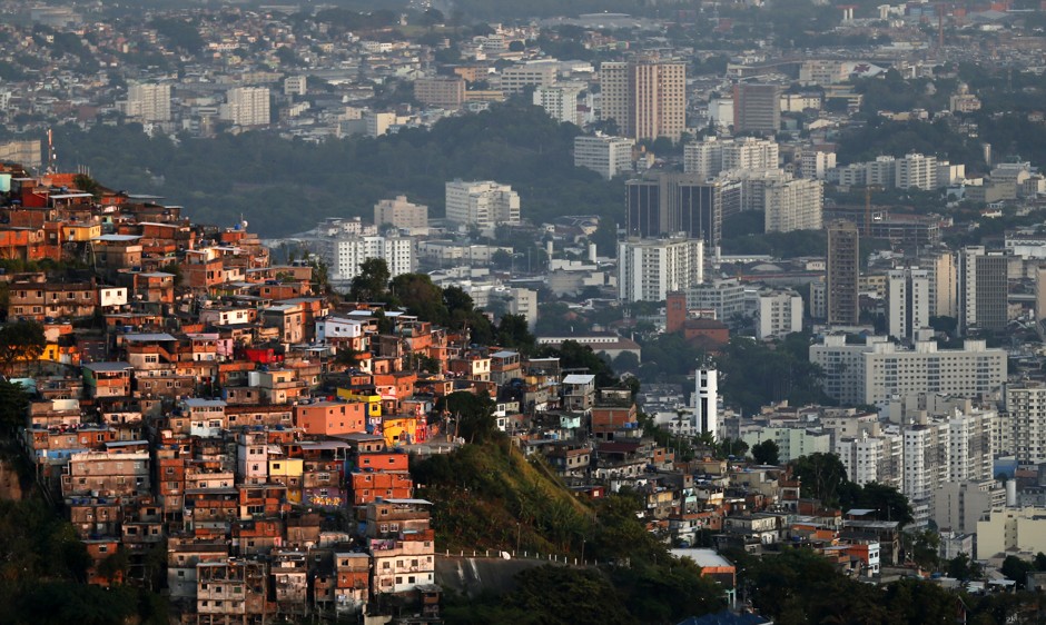
The largest of these neighborhoods bears the name of Rosinha, His brick and concrete houses are crowded on a hill in Rio de Janeiro. While official records indicate that it is home to 70,000 people, Other estimates put it with a population of more than 100,000. today The city of Rio de Janeiro is working with MIT’s Cinstable City Lab to draw the first digital map to fully encompass Rosinha.
But what is interesting is that the population varies in living standards even within Rosinha. People living up the hill have to walk to reach their homes and have great difficulties accessing jobs and services.
Like other governments, The Brazilian government’s efforts to eradicate slums have not succeeded. Rapid migration to cities has been faster than all twentieth-century projects.
Most of the neighborhood’s homes have electricity and running water. But sewage constantly flows through a large canal that runs through busy streets full of garbage with neither names nor numbers. Besides these health risks, The modesty of government administration of these areas is complementary, With the scarcity of economic opportunities and social segregation, Slum dwellers have left victims of harsh living conditions, the spread of disease and frequent violence. As a result, The average life expectancy of the population in these neighborhoods was 48 years. That’s 20 years below the national average.
Hence the need for a project aimed at providing a clearer and more accurate understanding of these neighborhoods. The project bears the name of four-dimensional shantytowns, It aims to study urban form from a quantitative perspective by using data analysis techniques to describe morphological or morphological aspects and map them.
To put it simpler, The researchers created a virtual model of the area using light range determination (lidar) technology. It is a three-dimensional laser scanning technology, It sends infrared pulses and then measures how long it takes for those pulses to bounce off the target objects, The output is an accurate representation of the built environment, no matter how complex it is, This is what we call a multidimensional map.
To get to this point, Field teams toured the alleys of Rosinha with scanners storing information for each foothold on an area of 1.5 square kilometers. At the current pace of work, orphan
Create about 300,000 data points every second, So that the cost of the entire surveys will not exceed $ 60,000, Which will be quickly compensated by the services that the map will provide to the population.
Data is analyzed at two levels, The first compares the streets of shantytowns, The second examines the morphological differences within each street according to 5 factors, They are the width and height of the street, the density and heights of its facades, and the ratio of these heights to the dimensions of the street.
These efforts have revealed many of the problems facing these neighborhoods at the level of infrastructure, Such as the real estate trade due to limited land tenure, the risk of landslides, Poor air and water quality.
The Brazilian experience was inspired by Colombia’s model at the turn of the century to build a cable car network and integrate the people of these communities by opening libraries and parks in their neighborhoods. This approach has established itself as the gold standard for governments’ commitment to serving their societies without exception. It spread to Latin America and from there to the world.
This project is nothing more than a simple step to solve a deep-rooted problem, It is necessary to think about its first causes, From social inequality to irregular migration that is accelerating today due to climate change. Hence, Governments need more comprehensive strategies, They must plan urban environments to be better able to accommodate different societal groups, And to provide affordable housing options for all.
These surveys will also raise legitimate concerns about data privacy. It is an issue that requires additional attention from the authorities to establish acceptance among the residents of the neighborhood, In particular, the map will help improve their living conditions and access to public services, It will facilitate the creation of property records and save the time and cost you need.
These efforts will provide an abundant resource for everything related to slums, Its details and construction patterns will be revealed, This will benefit researchers and scholars in various fields such as development, sociology and architecture. It will also provide a solid ground of information that decision-makers can refer to in planning future policies and building healthier cities.
References:
https://www.weforum.org/agenda/2022/08/mit-favelas-brazil-lidar/