With the increasing frequency and intensity of wildfires, innovative solutions have taken flight, literally. The use of airships equipped with advanced sensors has emerged, monitoring areas from high altitudes and collecting real-time data, thus changing the way we deal with fires.
Fire, humanity's greatest ally and most formidable enemy, is a paradox. It fuelled development, providing warmth, cooking, light, and energy. Yet, it can instantly transform into an uncontrollable destructive force.
Once it spirals out of control, fire can devastate communities and ecosystems, claiming lives and consuming green cover relentlessly. This phenomenon, known as wildfires, poses a growing threat today due to climate change and human factors. The recent fires in Los Angeles are a stark reminder of these escalating risks.
Historically, pinpointing the locations and times of fire outbreaks has been challenging. Traditional methods of wildfire detection are often limited. Satellites, for instance, often provide low-resolution images and, worse, are slow to reach those who need them, arriving too late. Aircraft and helicopters, while offering accurate and detailed images, are prohibitively expensive and may be too close to provide a complete picture of the scene. More importantly, they pose a real risk to the lives of pilots flying over raging fire zones. While drones are safer and more cost-effective, their flight times and altitude capabilities are limited.
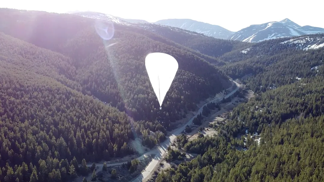
A challenge of this magnitude naturally demands an out-of-the-box approach. The American company Urban Sky has taken the lead in using high-altitude airships to detect, monitor, and track wildfires.
This company and its counterparts leverage their expertise in "lighter-than-air" technologies to develop and deploy advanced airship systems that can operate autonomously at high altitudes. They collect real-time information, measure ground-level temperatures, detect fires from above, and send early detection signals to fire response teams for rapid action.
The company's approach involves launching airships from pickup trucks, filled with compressed hydrogen or helium and tethered to a mast extending from the same truck. As it ascends, the airship fills with gas particles lighter than the surrounding air, allowing it to rise higher and higher, without interfering with airspace traffic or the fires themselves. The airship can then hover over carefully selected locations using weather programs, ensuring it moves at the correct altitudes above the fires. This launch process takes about 10 minutes. Once a fire is located, the airships can hover over the fire for approximately 18 hours, taking advantage of weather conditions.
Equipped with an infrared sensing system, these airships provide real-time, clear images of hotspots with an accuracy of 3.5 meters during these hours, allowing for the detection of individual damaged trees. The onboard processor sends real-time information about hotspots to ground crews via satellite communication networks.
The company faced numerous challenges while developing and deploying this system. One of the most prominent was ensuring the accuracy of the sensors in determining geographic location. To address this, the company invested in upgrading the hardware technology and broadcast capabilities to ground receiving stations.
Another challenge was developing a reliable communication system to transmit data from the sensors directly to firefighting crews on the ground. This required collaboration with multiple partners, including leaders in advanced communication and information exchange technology.
However, the biggest challenge was related to the method of managing and operating the airships at high altitudes. They would have to withstand changing weather conditions and maintain stability while collecting data. It was also necessary to ensure their operability without human intervention. These were operational challenges related to proof of concept and required considerable development and research efforts to keep risks to a minimum and efficiency to a maximum, especially with several companies working to upgrade them to monitor wind directions, fly for months, operate within fleets, or rely on solar energy.
As a result of these efforts, the innovative approach has yielded significant results. The technology has received attention and government funding. The company secured partnership with NASA's Earth Science Technology Office, with a value large enough to enable it to enhance the accuracy of its sensors, improve data transmission capabilities, and develop a robust communication system with ground teams.
The airships have proven effective in detecting fires, monitoring their spread, and mapping, all without the need for human intervention or putting them at risk. This allows field teams to deal with fires efficiently, predict them, and mitigate their severity, thereby saving vast areas of lives, land, and livelihoods.
As this technology continues to evolve, it promises future possibilities, great expansion, and better protection for environments and communities.
References
- MIT Technology review - tracking wildfires
- Forest service testing hot air balloons to track wildfires
- Tethered hot air balloons in Marseilles, France
- Urbansky wins NASA contract
- EU funded projects to tackle wildfires
- Raven Aerostar technology to tackle wildfires
- Aerostar website
- https://www.bbc.com/news/articles/c1m5r5zp0lno